Search:
Google images eBay wikipedia YouTube

(
52.55703,
-0.3359)
Map/aerial photo of the area around the mill
Tower mill function:Corn mill
Entry in Mills Archive database -
#2275 - Tower mill, Castor

The River Nene looking towards Castor Windmill
[2011-05-22]
- HD
Marathon


The River Nene looking towards Castor Windmill and Watermill
[2011-05-22]
- HD
Marathon

The remains of Castor Windmill
[2011-05-22]
- HD
Marathon

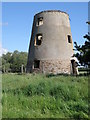
Old windmill at Castor Mill
[2005-08-21]
Steve Edge
(5) Geograph images are licenced under a Creative Commons Attribution-Share Alike licence
tower millPhotos: (1) Stainwright (a) derelict with broken stocks, early C20 (b) capless tower, 1988 (2) A C Smith (WIHAP) (a) capless tower, September 1972
Flickr images are copyright their individual photographers.
Images from Historic England - hover over image to see copyright info, and to enable zoom
Mill Road, Castor, Peterborough, Cambridgeshire
31 May 2003 - Photograph (Digital)
|
International Mill Database Entry |
|---|
| name |
Black Dike Mill |
| id |
59626 |
| description |
Disused tower mill, no technique, left abandoned |
| drive power recent |
none |
| drive power originally |
windmill |
| mill type |
tower mill |
| function type |
grain mill |
| condition type |
abandoned |
| map location |
52.55704,-0.33597 |
| country |
United Kingdom |
| state |
England |
| county |
Cambridgeshire |
| municipality |
Peterborough |
| city |
Castor |
| zip |
PE5 7BT |
| street |
Mill Lane |
| logo detail |
windmill_nophoto |