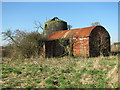
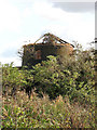
Norton Subcourse windmill, Norfolk 🌍


Norton Subcourse #2199

Search: Google images eBay wikipedia YouTube

(52.55204,1.54122)


Map/aerial photo of the area around the mill

Boyce's Dyke Mill: Tower mill function:Drainage mill

Entry in Mills Archive database - #2199 - Boyce's Dyke Mill, Norton Subcourse

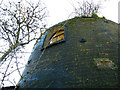
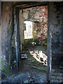
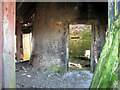
Derelict drainage pump east of Ferry Road, Nogdam [2011-03-08]

Evelyn Simak

Derelict drainage pump east of Ferry Road, Nogdam [2011-03-08]

Evelyn Simak

Derelict drainage pump east of Ferry Road, Nogdam [2011-03-08]

Evelyn Simak

Derelict drainage pump east of Ferry Road, Nogdam [2011-03-08]

Evelyn Simak

Derelict drainage pump east of Ferry Road, Nogdam [2011-03-08]

Evelyn Simak

Derelict drainage pump east of Ferry Road, Nogdam [2011-03-08]

Evelyn Simak

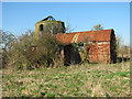
Derelict drainage mill east of Ferry Road [2009-10-04]

Evelyn Simak

Derelict drainage mill east of Ferry Road [2009-10-04]

Evelyn Simak

Derelict mill near Nogdam End [2008-05-03]

Pierre Terre

(9) Geograph images are licenced under a Creative Commons Attribution-Share Alike licence

for information on Boyce's Dyke Mill, Norton Subcourse
International Mill Database Entry
name Boyce's Dyke drainage mill
id 57444
description Disused brick drainage mill, left abandoned
drive power recent none
drive power originally windmill
mill type tower mill
function type drainage
condition type abandoned
map location 52.55204,1.54122
country United Kingdom
state England
county Norfolk
municipality Norwich
city Norton Subcourse
city part Nogdam End
zip NR14 6SE
street Ferry Road
logo detail windmill_tower
picture 138858
photographer name Ton Meesters
Website link Norfolk Mills
picture name GB-NortonSubcourseNorfolkBoycesDykeMill_01_ID57444_TonMeesters_1996.JPG
picture url https://milldatabase.org/image/138858/download


[Windmills] [Watermills] [Bookshop] [News and Blog] :

Last generated 20/10/2026 Text and images © Mark Berry, 1997-2026 -