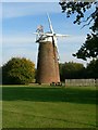
East Dereham
#2118
Search:
Google images eBay wikipedia YouTube
(
52.67734 ,
0.96202 )
Map/aerial photo of the area around the mill
Tower mill function:Corn mill
- Latest restoration 2013. Now operated as a Community Exhibition Centre
Plaque says:
Dereham Windmill
[
homepage ]
[
info ]
Entry in Mills Archive database -
#2118 - Tower mill, East Dereham
Housing Estate at Dereham
[2010-07-10]
- HD
Ashley Dace
(6) Geograph images are licenced under a Creative Commons Attribution-Share Alike licence
Details from Norfolk Mills .
Associated charity
#1108549
- Dereham Windmill
Wikipedia entry
Flickr images are copyright their individual photographers.
Show 178 Flickr images
Images from Historic England - hover over image to see copyright info, and to enable zoom
Norwich Lane, Dereham, Breckland, Norfolk
14 Jul 2002 - Photograph (Digital)
International Mill Database Entry
name
East Dereham Windmill
id
50132
description
Tower mill built in 1836, restored in the 1980s with only few parts of the machinery
preserved and serving as a community exhibition centre since 2013
drive power recent
windmill
drive type recent
sails
mill type
tower mill
function type
grain mill
condition type
technique
use today
exhibition space
map location
52.677385,0.962005
country
United Kingdom
state
England
county
Norfolk
municipality
Dereham
city
Dereham
zip
NR20 3TE
street
Greenfields Road
logo detail
windmill
sails
shuttered
luffing
fantail
picture
138230
photographer name
Ton Meesters
Website link
Norfolk Mills
construction year
1836
picture name
GB-EastDerehamNorfolkTowerMill_01_ID50132_TonMeesters_1996.jpeg
picture url
https://milldatabase.org/image/138230/download


 (