Search:
Google images eBay wikipedia YouTube

(
52.63081,
-0.5653)
Map/aerial photo of the area around the mill
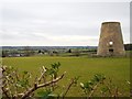
Tower mill function:Corn mill
- Within land owned by Castle Cement, but field is explicitly excluded from being quarried for limestone
[
info]
Entry in Mills Archive database -
#1550 - Tower mill, Ketton
(5) Geograph images are licenced under a Creative Commons Attribution-Share Alike licence
Listed Building, Grade II:
WINDMILL
(listed 1984-12-17)
Flickr images are copyright their individual photographers.
Images from Historic England - hover over image to see copyright info, and to enable zoom
Windmill, Empingham Road, Ketton, Rutland
28 Aug 2003 - Photograph (Digital)


