Woodhorn
#1369
Search:
Google images eBay wikipedia YouTube

(
55.19633,
-1.5323)
Map/aerial photo of the area around the mill
Tower mill function:Corn mill
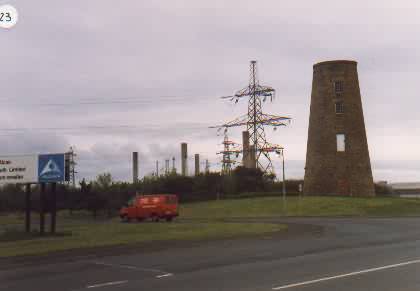
Woodhorn,
, 25/5/89
© Peter Hedges collection
Entry in Mills Archive database -
#1369 - Tower mill, Woodhorn
[
SINE database]
[
SINE database]
[
SINE database]
[
SINE database]
[
SINE database]
[
Co-Curate]
(10) Geograph images are licenced under a Creative Commons Attribution-Share Alike licence
Flickr images are copyright their individual photographers.
Images from Historic England - hover over image to see copyright info, and to enable zoom
Old Windmill, Ashington, Wansbeck, Northumberland, NE63 9YA
10 May 2001 - Photograph (Digital)
|
International Mill Database Entry |
|---|
| name |
Woodhorn Windmill |
| id |
34779 |
| description |
Tower mill with reefing stage, now abandoned |
| drive power recent |
none |
| drive power originally |
windmill |
| mill type |
tower mill |
| special construction |
reefing stage |
| function type |
grain mill |
| condition type |
abandoned |
| map location |
55.196355,-1.532365 |
| country |
United Kingdom |
| state |
England |
| county |
Northumberland |
| municipality |
Ashington |
| city |
Woodhorn |
| zip |
NE63 9YN |
| logo detail |
windmill_tower |
| picture |
13110 |
| photographer name |
Leo van der Drift |
| floors count |
2 |
| picture name |
uk_ashingtonwoodhornnorthumerlandwoodhornmill_leovanderdrift.jpg |
| picture url |
https://milldatabase.org/image/13110/download |


